| Weather at Mile 0 Catalina Highway, Tucson (12NE) | |||
|---|---|---|---|
| LAST READING AT TIME: 9:40 PM DATE: June 12 2026, time of next update: 9:50 pm | |||
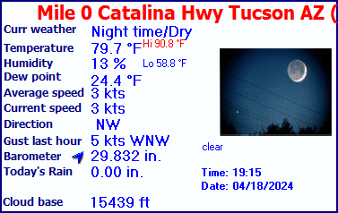
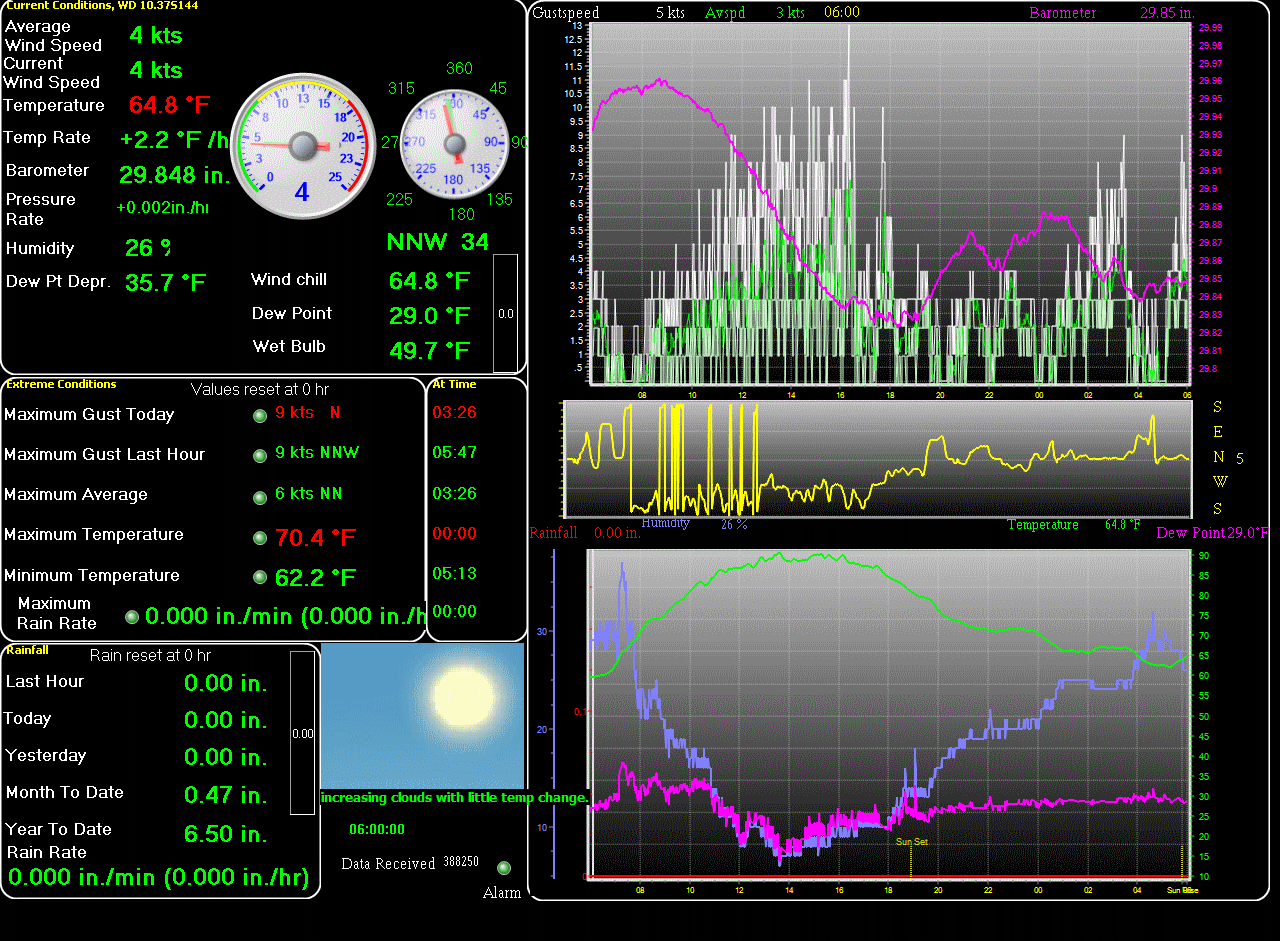
| Current Weather | ---/Night | Current Temperature | 92.7°F (33.7°C) (Heat Index 89.6°F ), Apparent temp 93.7°F |
| Maximum Temperature (since midnight) | 107.5°F at: 2:53 PM | Minimum Temperature (since midnight) | 78.2°F at: 5:46 AM |
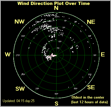
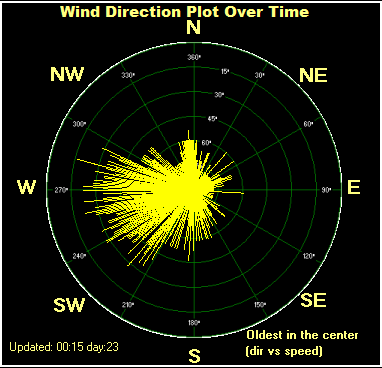
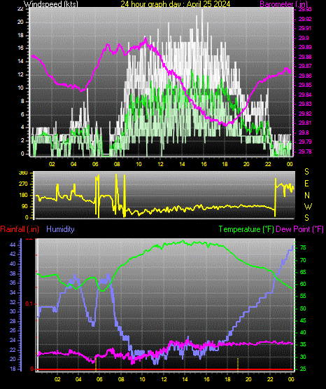
| Average windspeed (ten minute) | 1.1 kts (2.0 kmh) | Wind Direction (ten minute) | ESE (114°) |
| Heat Index | 89.6°F | Maximum Gust (last hour) | 15.7 kts (29.0 kmh) at: 8:45 PM |
| Maximum Gust (since midnight) | 20.0 kts (37.0 kmh) at: 5:50 PM | Maximum 1 minute average (since midnight) | 15.4 kts (28.4 kmh) at: 7:28 PM |
| Rainfall (last hour) | 0.00 in. (0.0 mm) | Rainfall (since midnight) | 0.00 in. (0.0 mm) --- |
| Rainfall This month | 0.00 in. (0.0 mm) | Rainfall To date this year | 3.22 in. (81.8 mm) |
| Maximum rain per minute (last hour) | 0.00 in/min | Maximum rain per hour (last 6 hours) | 0.00 in/hour |
| Yesterdays rainfall | 0.00 in | DewPoint | 49.5°F (Wet Bulb :67.7°F ) |
| Humidity | 23 %, Humidex 94.8°F | Barometer corrected to msl | 29.717 in. (1006.3 hPa) |
| Pressure change | +0.03 in. (last hour) | Trend (last hour) | RISING SLOWLY |
| Pressure change (last 12 hours) | -0.08 in | Pressure change (last 6 hours) | +0.06 in |
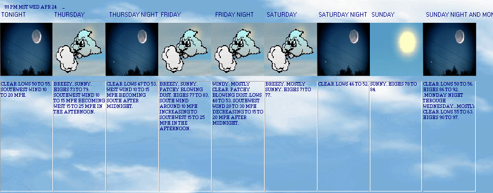

Expires:202606131400;;638690
FPUS55 KTWC 122113
ZFPTWC

Zone Forecast Product for Southeast Arizona
National Weather Service Tucson AZ
212 PM MST Fri Jun 12 2026


AZZ504-131400-
Tucson Metro Area-
Including Tucson, Green Valley, Marana, and Vail
212 PM MST Fri Jun 12 2026

.TONIGHT...Partly cloudy. Lows 72 to 78. Northwest wind 5 to
15 mph becoming southwest around 5 mph after midnight.
.SATURDAY...Mostly sunny. A 10 percent chance of showers and
thunderstorms in the afternoon. Highs 97 to 103. West wind around
5 mph becoming northwest 5 to 15 mph in the afternoon.
.SATURDAY NIGHT...Mostly clear. A 10 percent chance of showers
and thunderstorms in the evening. Lows 71 to 77. Northwest wind
5 to 15 mph becoming southwest around 10 mph after midnight.
.SUNDAY...Sunny with chance of showers and slight chance of
thunderstorms. Highs 98 to 104. Southwest wind around 5 mph
becoming west 5 to 15 mph in the afternoon. Chance of
precipitation 30 percent.
.SUNDAY NIGHT...Mostly clear. Lows 70 to 78. West wind 5 to
15 mph becoming south around 10 mph after midnight.
.MONDAY...Mostly sunny. Highs 97 to 103.
.MONDAY NIGHT...Partly cloudy. Lows 70 to 76.
.TUESDAY...Mostly sunny. Highs 98 to 104.
.TUESDAY NIGHT AND WEDNESDAY...Mostly clear. Lows 70 to 76. Highs
97 to 103.
.WEDNESDAY NIGHT...Partly cloudy with a 10 percent chance of
showers and thunderstorms. Lows 70 to 76.
.THURSDAY...Mostly sunny with a 10 percent chance of showers and
thunderstorms. Highs 95 to 101.
.THURSDAY NIGHT...Partly cloudy with a 20 percent chance of
showers and thunderstorms. Lows 67 to 73.
.JUNETEENTH...Mostly sunny. Highs 95 to 101.

$$


TUCSON INTERNATIONAL AIRPORT , AZ, United States (KTUS) 32-08N 110-57W 786M
May 23, 2026 - 10:53 AM EDT / 2026.05.23 1453 UTC
Wind: from the SE (140 degrees) at 6 MPH (5 KT):0
Visibility: 10 mile(s):0
Sky conditions: clear
Temperature: 75.0 F (23.9 C)
Dew Point: 42.1 F (5.6 C)
Relative Humidity: 30%
Pressure (altimeter): 30.01 in. Hg (1016 hPa)
Pressure tendency: 0.06 inches (2.0 hPa) higher than three hours ago
ob: KTUS 231453Z 14005KT 10SM CLR 24/06 A3001 RMK AO2 SLP115 T02390056 53020
cycle: 15
Davis-Monthan Air Force Base, AZ, United States (KDMA) 32-10N 110-53W
May 23, 2026 - 03:55 AM EDT / 2026.05.23 0755 UTC
Wind: from the SE (140 degrees) at 5 MPH (4 KT):0
Visibility: 10 mile(s):0
Sky conditions: clear
Temperature: 71.4 F (21.9 C)
Dew Point: 35.6 F (2.0 C)
Relative Humidity: 26%
Pressure (altimeter): 29.92 in. Hg (1013 hPa)
ob: KDMA 230755Z AUTO 14004KT 10SM CLR 22/02 A2992 RMK AO2 SLP088 T02190020 TSNO
cycle: 8
Date: 6/12/2026
Sunrise at:
05:15 am

Sunset at:
07:29 pm

Moonrise at:
02:40 am 06/12/26

Moonset at:
---

First Quarter  May 23 2026
Full moon  May 31 2026
Last QuarterJune 8 2026
New moon June 15 2026
Moon age: 25 days,22 hours,2 minutes,14%
Hours of possible daylight today was 14:14:00
Use the RELOAD facility on your browser to retrieve the latest data.